

Batam Map: Districts, Postcodes & Ferry Terminals
Batam's 12 districts and 64 kelurahan with boundaries and postcodes, 34 landmarks, Trans Batam bus stops, ferry times to Singapore and 6,166 places from the BATAM.co.id business directory. Search a place or postcode, or press My location.
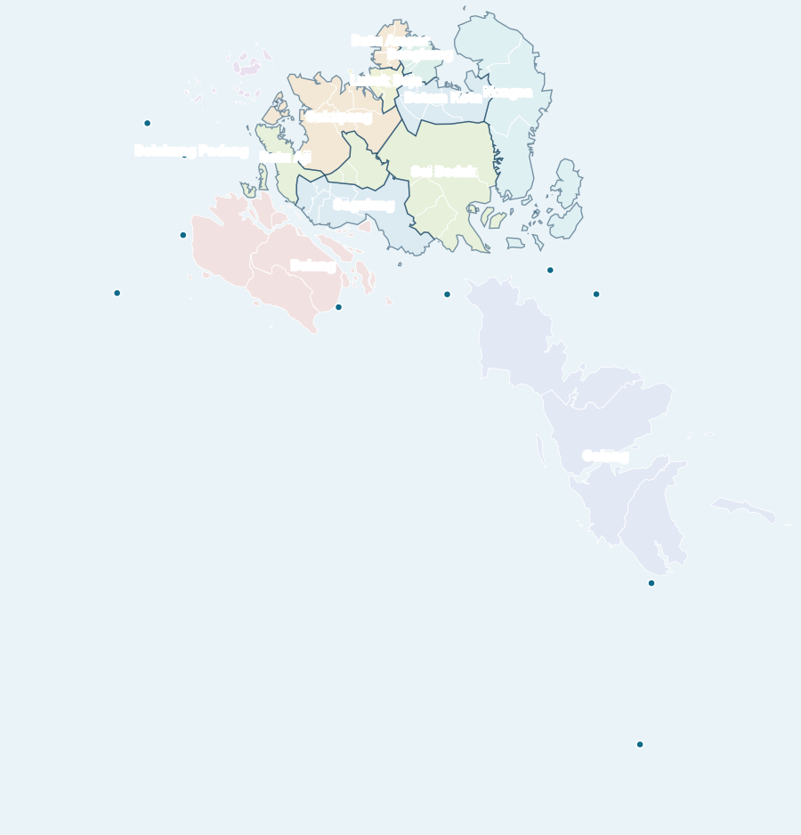
Long-press (phone) or right-click the map to see what is around that point: kelurahan, postcode, number of places and estimated travel time to a ferry terminal or the airport. Map: OpenFreeMap · © OpenStreetMap contributors.
Key facts · data as of 20 October 2026
- Batam City is divided into 12 districts (kecamatan) and 64 kelurahan; Galang has the most kelurahan (8).
- Official kelurahan postcodes in Batam run from 29411 to 29496; one postcode can cover several kelurahan.
- OpenStreetMap has boundaries for 9 districts on Batam Island and 54 of 64 kelurahan; the island districts Belakang Padang, Bulang and Galang have no district boundary yet, and 10 island kelurahan are shown as dots.
- The map shows 34 landmarks, 80 more sights, 50 Trans Batam stops and Singapore ferry times from 5 Batam terminals (WIB and SGT).
- The "Work & industry" view outlines 52 named industrial sites from OpenStreetMap, 27 of them industrial estates, each with its kelurahan and mapped area.
- The BATAM.co.id directory lists 6,166 places with coordinates; the most are in Belian (477).
Districts, kelurahan and postcodes in Batam
All 12 districts and 64 kelurahan of Batam City with their postcodes. Place counts come from the BATAM.co.id business directory.
Batam Kota district
Batam Kota has 6 kelurahan with official postcodes 29411–29415 and 1,524 places in our directory. Show on the map
| Kelurahan | Postcode | Places |
|---|---|---|
| Baloi Permai | 29413 / 29431 | 263 |
| Belian | 29414 / 29464 | 477 |
| Sukajadi | 29415 / 29432 | 82 |
| Sungai Panas | 29412 / 29433 | 177 |
| Taman Baloi | 29413 / 29432 | 173 |
| Teluk Tering | 29411 / 29461 | 352 |
Batu Aji district
Batu Aji has 4 kelurahan with official postcodes 29441–29444 and 569 places in our directory. Show on the map
| Kelurahan | Postcode | Places |
|---|---|---|
| Bukit Tempayan | 29443 / 29438 | 106 |
| Buliang | 29441 / 29438 | 229 |
| Kibing | 29442 / 29422 | 111 |
| Tanjung Uncang | 29444 / 29424 | 123 |
Batu Ampar district
Batu Ampar has 4 kelurahan with official postcodes 29421–29424 and 422 places in our directory. Show on the map
| Kelurahan | Postcode | Places |
|---|---|---|
| Batu Merah | 29422 / 29452 | 17 |
| Kampung Seraya | 29424 / 29454 | 87 |
| Sungai Jodoh | 29423 / 29453 | 237 |
| Tanjung Sengkuang | 29421 / 29453 | 81 |
Belakang Padang district
Belakang Padang has 6 kelurahan with official postcodes 29491–29496 and 3 places in our directory; its district boundary is not in OpenStreetMap yet. Show on the map
| Kelurahan | Postcode | Places |
|---|---|---|
| Kasu (dot) | 29493 / 29413 | 0 |
| Pecong (dot) | 29494 / 29414 | 0 |
| Pemping (dot) | 29492 / 29412 | 0 |
| Pulau Terong (dot) | 29496 / 29416 | 0 |
| Sekanak Raya | 29495 / 29416 | 3 |
| Tanjung Sari | 29491 / 29416 | 0 |
Bengkong district
Bengkong has 4 kelurahan with official postcodes 29426–29429 and 692 places in our directory. Show on the map
| Kelurahan | Postcode | Places |
|---|---|---|
| Bengkong Indah | 29427 / 29458 | 87 |
| Bengkong Laut | 29428 / 29458 | 161 |
| Sadai | 29426 / 29432 | 268 |
| Tanjung Buntung | 29429 / 29432 | 176 |
Bulang district
Bulang has 6 kelurahan with official postcodes 29471–29476 and 0 places in our directory; its district boundary is not in OpenStreetMap yet. Show on the map
| Kelurahan | Postcode | Places |
|---|---|---|
| Batu Legong | 29474 | 0 |
| Bulang Lintang | 29471 | 0 |
| Pantai Gelam | 29473 | 0 |
| Pulau Buluh | 29472 | 0 |
| Setokok (dot) | 29476 | 0 |
| Temoyong (dot) | 29475 | 0 |
Galang district
Galang has 8 kelurahan with official postcodes 29481–29487 and 5 places in our directory; its district boundary is not in OpenStreetMap yet. Show on the map
| Kelurahan | Postcode | Places |
|---|---|---|
| Air Raja (dot) | 29483 | 0 |
| Galang Baru (dot) | 29484 | 0 |
| Karas | 29486 | 1 |
| Pulau Abang (dot) | 29487 | 0 |
| Rempang Cate | 29482 | 1 |
| Sembulang | 29481 | 1 |
| Sijantung | 29485 | 2 |
| Subang Mas (dot) | 29483 | 0 |
Lubuk Baja district
Lubuk Baja has 5 kelurahan with official postcodes 29431–29436 and 890 places in our directory. Show on the map
| Kelurahan | Postcode | Places |
|---|---|---|
| Baloi Indah | 29436 / 29432 | 104 |
| Batu Selicin | 29431 / 29441 | 281 |
| Kampung Pelita | 29433 / 29443 | 91 |
| Lubuk Baja Kota | 29434 / 29444 | 369 |
| Tanjung Uma | 29435 / 29445 | 45 |
Nongsa district
Nongsa has 4 kelurahan with official postcodes 29416–29419 and 326 places in our directory. Show on the map
| Kelurahan | Postcode | Places |
|---|---|---|
| Batu Besar | 29416 / 29466 | 173 |
| Kabil | 29417 / 29467 | 120 |
| Ngenang | 29416 / 29468 | 0 |
| Sambau | 29419 / 29465 | 33 |
Sagulung district
Sagulung has 6 kelurahan with official postcodes 29451–29456 and 653 places in our directory. Show on the map
| Kelurahan | Postcode | Places |
|---|---|---|
| Sagulung Kota | 29451 / 29439 | 125 |
| Sungai Binti | 29453 / 29439 | 110 |
| Sungai Langkai | 29455 / 29439 | 104 |
| Sungai Lekop | 29454 / 29439 | 52 |
| Sungai Pelunggut | 29456 / 29439 | 59 |
| Tembesi | 29452 / 29439 | 203 |
Sei Beduk district
Sei Beduk has 4 kelurahan with official postcodes 29461–29464 and 320 places in our directory. Show on the map
| Kelurahan | Postcode | Places |
|---|---|---|
| Duriangkang | 29461 / 29437 | 71 |
| Mangsang | 29462 / 29437 | 146 |
| Muka Kuning | 29463 / 29433 | 39 |
| Tanjung Piayu | 29464 / 29437 | 64 |
Sekupang district
Sekupang has 7 kelurahan with official postcodes 29445–29449 and 744 places in our directory. Show on the map
| Kelurahan | Postcode | Places |
|---|---|---|
| Patam Lestari | 29447 / 29427 | 180 |
| Sungai Harapan | 29448 / 29428 | 110 |
| Tanjung Pinggir | 29448 / 29428 | 25 |
| Tanjung Riau | 29445 / 29425 | 109 |
| Tiban Baru | 29449 / 29426 | 116 |
| Tiban Indah | 29446 / 29426 | 156 |
| Tiban Lama | 29445 / 29425 | 48 |
The second postcode (after the slash) is the one commonly written in addresses. Full postcode list: kode pos Batam (Indonesian).
Islands of Batam City
Besides Batam Island, the city covers Rempang and Galang, linked by the Barelang bridges, and the islands of the Belakang Padang, Bulang and Galang districts. Island kelurahan without a boundary in OpenStreetMap are shown as dots: Kasu, Pecong, Pemping, Pulau Terong, Setokok, Temoyong, Air Raja, Galang Baru, Pulau Abang, Subang Mas.
Landmarks on the map
- A2 Food Court Nagoya
- Angkringan Tepi Danau Bengkong (ATD)
- Bandara Internasional Hang Nadim Batam
- Batam City Square (BCS Mall)
- Batam Zoo Paradise
- Belalang Adventure Batam
- Dino's Gate Batam
- Golden City Go-Kart Batam
- Golden Prawn 933 Batam
- Grand Batam Mall
- Harbour Bay Batam
- Infinity Beach Club Batam
- K Square Batam (eks Kepri Mall)
- Love Seafood Batam Centre
- Maha Vihara Duta Maitreya Batam
- Mal Botania 2
- Masjid Agung Raja Hamidah Batam
- Mega Mall Batam Centre
- Mega Wisata Ocarina Batam
- Nagoya Hill Shopping Mall
- Nongsa Point Marina & Resort
- One Batam Mall
- Panbil Mall
- Pantai Tanjung Pinggir
- Park Avenue Batam
- Pelabuhan Batu Ampar
- Pelabuhan Feri Internasional Batam Centre
- Pelabuhan Gold Coast Bengkong
- Pelabuhan Sekupang
- Pelabuhan Telaga Punggur
- Puncak Beliung Sekupang
- Taman Pantai Golden Prawn
- Terminal Feri Nongsapura
- Tulisan Welcome to Batam (Bukit Clara)
Restaurants, hotels, pharmacies and other businesses are in the Batam business directory; hotels in English at Batam hotels. To plan a day out, use the Batam Trip Planner.
Frequently asked questions
How many districts does Batam have?
Batam City has 12 districts (kecamatan): Batam Kota, Batu Aji, Batu Ampar, Belakang Padang, Bengkong, Bulang, Galang, Lubuk Baja, Nongsa, Sagulung, Sei Beduk and Sekupang. Together they are divided into 64 kelurahan (urban sub-districts).
What is the postcode of Batam?
Each kelurahan in Batam has its own postcode. The official Pos Indonesia postcodes for Batam's 64 kelurahan run from 29411 to 29496; many addresses use a different, commonly written code. Search a kelurahan or a postcode on the map to see every kelurahan that uses it.
Which ferry terminals in Batam serve Singapore?
5 Batam terminals have Singapore sailings on the operators' timetables: Batam Centre, Harbour Bay, Sekupang, Nongsapura and Gold Coast Bengkong. Tap a terminal on the map for today's next departures in WIB and Singapore time. Singapore–Batam ferry guide
Where is the Barelang Bridge?
The Barelang bridges link Batam Island with Tonton, Nipah, Setokok, Rempang and Galang islands to the south. Choose Sights on the map to see the bridges and nearby places.
How do I find out which kelurahan I am in?
Press My location on the map. The kelurahan, district and postcode are worked out on your phone from OpenStreetMap boundaries; your location is not sent to our server. Without GPS, long-press the map or use Pick a point.
Related pages
Data sources
District and kelurahan boundaries come from OpenStreetMap and are simplified to stay light on a phone; island districts that are not mapped as areas are marked by their kelurahan place names, never by drawn-in lines. The kelurahan list and postcodes follow official data, places come from the BATAM.co.id business directory, and travel times use the same rush-hour model as our trip tools. Your location is worked out on your device and is not sent to our server.
| Data | Source | Updated |
|---|---|---|
| District & kelurahan boundaries | OpenStreetMap (ODbL) | 2026-10-20 |
| Kelurahan list & postcodes | Pos Indonesia; kelurahan list per Permendagri 72/2019 | 2 Oktober 2026 |
| Businesses | BATAM.co.id business directory | 2026-10-20 |
| Ferry times | Ferry operators' official websites | 2026-10-20 |
| Trans Batam stops | OpenStreetMap (ODbL) | 2026-10-12 |
| Industrial areas | OpenStreetMap (ODbL) | 2026-10-20 |
Data refresh automatically; the dates above are when each source was last read. Base map: OpenFreeMap · © OpenStreetMap contributors.
Cite as: Batam map — BATAM.co.id, data as of 20 October 2026, https://batam.co.id/expats/batam-map/
