

Barelang, Batam: The Six Bridges, Rempang and Galang Islands
- KM 0
- B1 · 21
- B5 · 53
- 76
Road distance from Batam Centre ferry terminal (shortest car route, OpenStreetMap data). B = Barelang bridge.
In short: Barelang is the name for Batam, Rempang and Galang islands, linked by a chain of six bridges inaugurated on 25 January 1998.
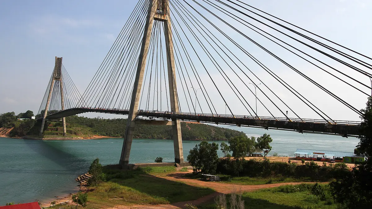
Barelang combines the names of Batam, Rempang and Galang, the islands linked by the six Barelang bridges. Building started in July 1992 and the bridges were inaugurated on 25 January 1998. From Batam Centre ferry terminal, Bridge 1 is about 21 km by road, the Galang refugee camp about 56 km and Elyora beach on Galang Baru about 76 km. Rempang and Galang belong to Galang district (kecamatan); Setokok, the small island you cross before Rempang, belongs to Bulang district. This guide lists every place on the route, nearest first.
Places along the route, nearest first
- 21 kmJembatan Barelang 1–6Batam · Bridge 1–64.6 ★ · Maps
- 30 kmPantai SetokokSetokok island · between Bridge 3 and 44.1 ★ · Maps
- 44 kmPantai Melayu RempangRempang · after Bridge 44.2 ★ · Maps
- 55 kmPantai MirotaGalang · after Bridge 54.3 ★ · Maps
- 56 kmKampung Vietnam (Camp Vietnam)Galang · after Bridge 54.3 ★ · Maps
- 57 kmPantai MelurGalang · after Bridge 54.1 ★ · Maps
- 58 kmPantai ViovioGalang · after Bridge 54.2 ★ · Maps
Names as listed locally; ratings from Google Maps (27 October 2026).
Pins from each place's Google Maps point. Map: OpenFreeMap · data © OpenStreetMap contributors.
Rempang Island
Rempang is the second large island in the chain, between Bridge 4 (from Setokok) and Bridge 5 (to Galang).
- Rempang covers about 165.83 km² and lies roughly 3 km south-east of Batam Island; Bridge 5 links it to Galang Island in the south. [source, Wikipedia]
- Sembulang, one of the eight kelurahan of Galang district, is on Rempang. [source, Wikipedia]
- Rempang Eco City is a national strategic project on the island, planned since 2004 with developer PT Makmur Elok Graha. On 7 September 2023 residents clashed with officers who were installing land markers. [source, Tirto, 2023]
- 44 km Melayu Beach, RempangRempang · 1,036 Google reviews 4.2 ★ · Maps · Directions
Rempang Eco City timeline (Indonesian)Pulau Rempang (Indonesian)
Galang Island
You reach Galang after Bridge 5. Bridge 6 continues to Galang Baru at the southern end of the chain.
- Galang is known for the refugee camp that operated from 1979 to 1996. [source, Wikipedia]
- In August 2025 the government named Galang as one of the alternative sites to treat about 2,000 people from Gaza; the foreign minister said other options were still being studied. [source, CNN Indonesia, 7 Aug 2025]
- Pulau Abang, a separate island and kelurahan of Galang district reached by boat, is a protected marine area known for snorkeling. [source, Kumparan, 2019]
- 56 km Galang Refugee Camp (Kampung Vietnam)Galang · 805 Google reviews 4.3 ★ · Maps · Directions
- 58 km Viovio BeachGalang · 1,349 Google reviews 4.2 ★ · Maps · Directions
- 57 km Melur BeachGalang · 317 Google reviews 4.1 ★ · Maps · Directions
- 55 km Mirota BeachGalang · 1,162 Google reviews 4.3 ★ · Maps · Directions
The six Barelang bridges
| No. | Name | Links | Length |
|---|---|---|---|
| 1 | Tengku Fisabilillah | Batam – Tonton | 642 m |
| 2 | Nara Singa | Tonton – Nipah | 420 m |
| 3 | Raja Ali Haji | Nipah – Setokok | 270 m |
| 4 | Sultan Zainal Abidin | Setokok – Rempang | 365 m |
| 5 | Tuanku Tambusai | Rempang – Galang | 385 m |
| 6 | Raja Kecik | Galang – Galang Baru | 180 m |
Source: Wikipedia, Barelang Bridge.
Barelang Bridge: all six bridges explained
Seafood and places to stay
Our Indonesian directory lists seafood restaurants and kelong (stilt restaurants over the water) and hotels in the Barelang and Galang area, with opening hours and ratings from Google Maps.
Seafood in Barelang & Galang (Indonesian)Hotels in Barelang & Galang (Indonesian)
Plan the day
The camp is about 56 km and Elyora beach about 76 km from Batam Centre ferry terminal by road. Our day-trip planner orders the stops and estimates travel time; the Batam map shows the kelurahan boundaries on Rempang and Galang.
Batam day trip itineraryBatam map
Frequently asked questions
What does Barelang stand for?
Barelang combines the names of three islands linked by the six Barelang bridges: Batam, Rempang and Galang.
How far is Barelang from Batam Centre ferry terminal?
By road, Bridge 1 is about 21 km, the Galang refugee camp about 56 km and Halona beach near Bridge 6 about 63 km from Batam Centre ferry terminal (shortest car route on OpenStreetMap data).
Which district are Rempang and Galang in?
Galang district (kecamatan Galang), Batam City. Setokok island, between Batam and Rempang, is in Bulang district.
Sources
- Wikipedia: Jembatan Barelang (Indonesian)
- Wikipedia: Pulau Galang (Indonesian)
- Wikipedia: Galang, Batam (Indonesian)
Baca dalam bahasa Indonesia: /barelang/
